|
|
 |
| SW Aviator Magazine is available in print free at FBOs and aviation-related businesses throughout the Southwest or by subscription. |

|
|

|
|
 |
|
|
The web's most comprehensive database of Southwest area aviation events.
|
|
|
|

|
|
|
Featured Site:
|
|
|
|
|
A continuosly changing collection of links to our favorite aviation related web sites.
|
|
|
|

|
|
|
|
|
A Vast Array
|
|
An Aerial Tour of Central New Mexico and the VLA
|
 By Cort Dougan By Cort Dougan
Central New Mexico offers a number of unique places to fly, and chief among them is the Very Large Array (VLA) radio astronomy observatory, the Cibola National Forest, and the historic town of Socorro. Recently, a friend of mine and I flew out to Socorro early in the morning to enjoy the New Mexico sunrise over the VLA, and flightsee the many interesting places in the Cibola National Forest along the way.
Belen and Ladron Peak
To prepare for our tour of the area we first stopped at the Belen Alexander airport, about 30 nm south of Albuquerque, for fuel and a bite to eat at their restaurant. The Belen airport sits atop a mesa that overlooks the town of Belen, to the east. On the mesa, the land climbs steadily toward the west into the mountains. Although the region is mountainous and density altitude can be a problem, flying through it is not terribly difficult, even for the moderately powerful Cessna 150 that we were flying. Large plains between relatively low mountain ranges and wide-open passes leave plenty of room to navigate. Despite that, be sure you know the area well before trying to navigate at night or take any risks. Search and rescue teams in the area have many stories about pilots who were careless that are less than flattering.
Right out of Belen, just to the west, is Ladron Peak. It bears the name of the Spanish word for thief. The name comes from the days of European settlement in the area that later became New Mexico when ladrones (thieves) hid in these mountains after robbing travelers on the royal highway (El Camino Real) from Mexico City to Santa Fe. Despite the many other high mountains in the area, Ladron’s 9,176 foot summit stands away from other mountains and is visible for miles around.
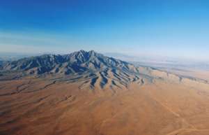
About 25 miles southwest of Belen, we quickly crossed into the Cibola National Forest. These forests came from what was once called the Forest Reserves. They were reserves created in the late 1800s in order to protect watersheds, trees, and soil. It’s commonly believed that the name Cibola was the name used by the Zuni Indians for the areas where their pueblos were. National Forest Service statistics show the Cibola National Forest is 1,625,542 acres in size, with elevation ranges from 5,000-11,301 feet. Our route took us directly over regions from 5,000-8,500. These areas receive a good bit of rainfall for a desert due to the monsoon season in late summer, and snow pack in winter. As a result, large trees (mostly Juniper and Ponderosa Pine) are plentiful.
Restricted Areas and a MOA
The route from Belen to the VLA and to Socorro passes very close to several restricted areas and a MOA. The VLA itself lies below the 13,500 floor of the CATO MOA. There is a restricted area just north of the VLA (R-5123) active intermittently by NOTAM, which is an impact area for rocket boosters launched from the Gallup area heading for the White Sands Missile Range for use as targets. Another restricted area lies in the mountains west of Socorro (R-5113), and is primarily active in the summer thunderstorm season as a lightning research center. R-5107C begins just east of Socorro. Obviously, a call to Flight Services for the status of these areas would be a good idea, as is a current sectional chart aboard your aircraft.
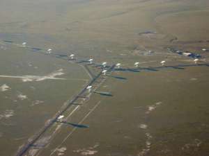
 The VLA The VLA
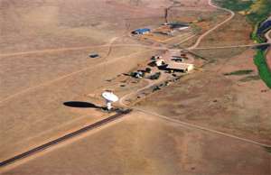
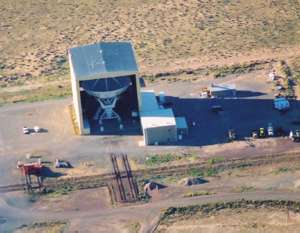
After crossing through the Cibola National Forest and cresting some low-lying hills, we saw the dishes of the Very Large Array in the Plains of San Agustin just over highway 60. The VLA is an arrangement of radio telescopes that is managed by the National Radio Astronomy Observatory, which sits just 35 nm west of Socorro, NM. It’s listed on the charts as “numerous radar dishes.” The VLA was prominently featured in the movie Contact. The site is unmistakable when viewed from the ground or air. It is made up of 27 187-ton, 82-foot wide, bright white dish-shaped radio receivers laid out in a Y-pattern in the middle of the desert, so it’s not a hard target to spot. Each of the three arms of the Y is nine miles long, and the location where the dishes are placed on those arms varies throughout the year, depending on the resolution the astronomers desire. So, on your visit, the antennas may be spread out the whole nine miles of each arm or be packed in tightly to just a mile.
We flew around the area, taking photos and enjoying the view for quite some time. The operations of the array are not harmful to aircraft and GA aircraft don’t interfere with the array. It is polite to stay well above the dishes, and it is necessary to watch out for other aircraft as this is under the CATO MOA.
The VLA facility is used by radio astronomers to study objects as “close” as the planets and as far as some of the farthest known objects in the universe. It has been the source of a number of scientific discoveries in astronomy and is worth a tour if you ever happen to be driving by.
Socorro
We left the VLA and headed east, toward Socorro. We passed north of Magdalena, a town that saw an enormous boom during the great mining and cattle years of the area. There is a nice dirt strip in Magdalena, which provides access to the town, and Rancho Magdalena Bed and Breakfast (covered in the Nov/Dec 01 issue of SW Aviator). We didn’t stop on this trip since we were headed for Socorro.
The Magdalena mountains that lie south of the town host a large collection of wildlife. More than 50 percent of the bird species that live in North America can be found here. These birds share the area with black bear, coyote, oryx, elk, mountain lions, and many more animals. There are some wonderful hikes along trails that follow streams through these mountains that can be reached via Water Canyon, just off highway 60.
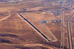
We came around the north side of Socorro Peak and landed in Socorro. The Socorro airport (KONM), elevation 4875 ft., has a large (5841 x 100 ft) 15/33 runway that was repaved in 2003 and looks wonderful. The 6/24 runway is usable, but a takeoff to the west would be a bit nerve-wracking since the ground rises quickly and there are some telephone poles and a highway a short way past the end of the runway.
Transportation into Socorro is provided by Socorro Taxi Service and car rental (800-991-4276). There is a phone at the Socorro airport, and be sure to mention that you are at the Socorro airport when you call, since the taxi service also offers transportation to the Albuquerque airport (75 miles away). Though the airport is currently unattended, fuel is readily available by calling the number listed at the airport (505-507-9096).
This town of 8,500 offers a lot for visitors to take in, far more than one can see in one day. For instance, there is the Trinity Site Atomic Test Area (open twice a year for tours), the NM Mineral Museum, the Langmuir Meteorology Research Lab, the historic San Miguel Mission and Juan Jose Baca Historical Home, the NM Fire Fighters Training Academy, and the Bosque del Apache Wildlife Refuge. There is also a walking tour of Socorro highlighting some of the historic architecture of the city. The walk was too long for us to start by the time we arrived, but it is definitely something worth a few hours of an afternoon on a more leisurely visit.
Stopping in Socorro for an early lunch presented us with a very hard choice for where to eat. There are a number of good Mexican restaurants, but we eventually decided to eat at the Socorro Springs Brewing Company. Even though the trip required a short cab ride (about 2 miles), it was certainly worth the time. They offer oven-roasted pizzas, calzones, salads, and sandwiches. The wonderful sounding selection of beers that are brewed on the premises had to wait until another trip when we could enjoy one (8 hours bottle to throttle). It turns out that one of the owners, Mic Heynekampof, is a pilot himself.
Although the winter weather was too cold for us to try it, the restaurant offers an atrium patio dining area with a pomegranate tree and hops plant. Large glass tables covered with umbrellas and sheltering walls made it look like a wonderful place to escape the summer heat with a cold beer.
The building that the Brewing Company shares with an art gallery, a real-estate office, a hydrology consulting group, and a software company is one of the oldest in Socorro. Across the street is the city hall and the abstract office that holds land and property deeds that go back a hundred years or more.
Our return flight took us north through the Rio Grande Valley. The river snakes along through a sandy bed that leaves many islands and unusual shapes in the water. Just north of Socorro is the La Joya Game Refuge. The area was originally named Geronimo Springs by rangers that discovered seepage at the base of sand dunes that created a 30-acre wetland. In 1948 it was purchased along with nearby land totaling 3,500 acres by the NM Department of Game and Fish. It was renamed La Joya Game Refuge and now consists of 6 inter-connected ponds criss-crossed with roads and levees. Even in the winter, it showed a great deal more green than the surrounding areas.
Flying Central New Mexico
A cautionary note about the area is important. The climate varies from blazingly hot and dry to freezing cold. Some of the higher areas are even very cold in the summers - especially at night. Make sure to know your route of travel, and the climate that you might encounter should you have to make an emergency landing. Water is scarce, so take as much as you would need for a couple of days in an emergency. Digital phone (PCS) coverage is nil in many of these remote areas, and analog phone coverage can be tricky, too. As always, filing a flight plan will greatly aid search and rescue should you need them. Especially in this area, ground searches can be difficult, so knowing what your flight path is can be invaluable to you and to them.
Our pleasant day trip to Socorro and through Central New Mexico confirmed that there are many diversions here for those interested in history, science, natural wonders, and outdoor activities. If you can, plan to spend a day or two in the region to enjoy all it has to offer. |
Click here to return to the beginning of this article. |
|