Editor's Note: Fremont Island is privately owned. Therefore, prior arrangements must be made with the owners before flying in.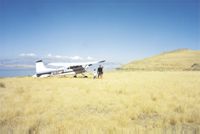 We regret any confusion which may have been caused by not mentioning this in the printed version of the October/November '99 SW Aviator. We regret any confusion which may have been caused by not mentioning this in the printed version of the October/November '99 SW Aviator.
The Great Salt Lake encompasses approximately 1700 square miles of the Great Basin in western Utah. It has, depending on water level, about seven islands. The largest of these, at 34 square miles, is Antelope Island, which rests in the southeast corner right next to Salt Lake City. Antelope Island is a state park with a fair amount of development and a herd of approximately 500 free-ranging buffalo. It's a nice place to visit, to be sure, but who wants to go where people who drive can go?
Just to the north of Antelope Island lies Fremont Island—at 14 square miles, the second largest island in the lake. It was named after John Charles Fremont, an explorer hired by the U.S. Government to explore the Great Basin in the Utah Territory. In 1835 he, along with the famous scout Kit Carson, traveled by canoe to the island to explore and survey it. While exploring the top, Kit Carson left evidence of his visit by carving a small cross in a rock, which can still be seen today. One of my favorite pleasures is to take friends up there and let them find the cross on their own. In that spirit, I will only tell you that the cross is somewhere on the rocky top at the very top of the island.
 The island has had only one set of permanent residents since Mormon pioneers first entered the Salt Lake Valley in 1847. In the 1880s, Judge U.J. Wenner, his wife, and their children moved to the island. The judge suffered from consumption and had been told that the island's air would be his best shot at improving his health. It worked...for a while. In the 1890s, the judge died of tuberculosis. The judge's wife, Kate, fashioned his grave, which quietly stands sentinel down on the southwest shore. Since that time, the only major activity on the island has been the off and on usage over the years for grazing sheep. The island has had only one set of permanent residents since Mormon pioneers first entered the Salt Lake Valley in 1847. In the 1880s, Judge U.J. Wenner, his wife, and their children moved to the island. The judge suffered from consumption and had been told that the island's air would be his best shot at improving his health. It worked...for a while. In the 1890s, the judge died of tuberculosis. The judge's wife, Kate, fashioned his grave, which quietly stands sentinel down on the southwest shore. Since that time, the only major activity on the island has been the off and on usage over the years for grazing sheep.
Fremont Island rises 500 ft. out of the Great Salt Lake and is grass-covered, with only two or three small trees clustered around a small spring on the south side. Notwithstanding the paucity of shade, there is plenty of charm to be found. It is totally undeveloped and untrammeled and the peace and tranquility encountered there must be experienced to be appreciated. Being only 20 minutes from my home airport of Bountiful Skypark (KBTF), I often go there in the early evenings just to enjoy the spectacular views and unparalleled sunsets.
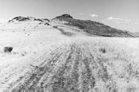 There are two strips suitable for landing on the island. Both are adequate for most planes, though the actual strips are narrow. One strip is located on the top ridge, which runs north and south down the spine of the island. It is about 1900 ft. long with wide flat grassy ground to the west. It drops off sharply and very abruptly to the east. The preferred way to land is from the south landing to the north. The rollout is fun with a small hill at the north end, which can be easily scaled with just a little bit of power. This makes the takeoff to the south quite fun with the initial drop down the hill to help you get going. The strip has a slight bend, which can be easily negotiated—about 600 ft. from the beginning of the usable ground on the south end. As the strip lies directly along the spine of the island it can have swirling air flowing over it and a low pass would be advised to assess the degree and severity of any crosswinds prior to landing. There are two strips suitable for landing on the island. Both are adequate for most planes, though the actual strips are narrow. One strip is located on the top ridge, which runs north and south down the spine of the island. It is about 1900 ft. long with wide flat grassy ground to the west. It drops off sharply and very abruptly to the east. The preferred way to land is from the south landing to the north. The rollout is fun with a small hill at the north end, which can be easily scaled with just a little bit of power. This makes the takeoff to the south quite fun with the initial drop down the hill to help you get going. The strip has a slight bend, which can be easily negotiated—about 600 ft. from the beginning of the usable ground on the south end. As the strip lies directly along the spine of the island it can have swirling air flowing over it and a low pass would be advised to assess the degree and severity of any crosswinds prior to landing.
The other strip is on the northwest corner of the island, running east and west in a wide-open grassy meadow down at water level. A nice, unobtrusive windsock has been placed to the southwest of the strip. This strip is approximately 1800 ft. long and can be approached from either end. It will easily accommodate a Cessna 172, and I have even seen a Cessna 150 out there—though it must have been light.
 The lower strip is the better of the two for inexperienced pilots and, though both strips are narrow, running off the runway on either side (except for the east side drop off on the upper strip) is not a problem. The ground is smooth and firm, and the truth is a landing just about anywhere on the island would be a non-event. However, those of us who use the island on a regular basis have endeavored not to spoil any more of the ground than is necessary. As with any back country strip, we try diligently to leave as minimal an impact as possible on those places we frequent. The lower strip is the better of the two for inexperienced pilots and, though both strips are narrow, running off the runway on either side (except for the east side drop off on the upper strip) is not a problem. The ground is smooth and firm, and the truth is a landing just about anywhere on the island would be a non-event. However, those of us who use the island on a regular basis have endeavored not to spoil any more of the ground than is necessary. As with any back country strip, we try diligently to leave as minimal an impact as possible on those places we frequent.
The upper strip is the best one for exploring the upper island and looking for Kit Carson's cross. The view alone makes it worth landing on top. To the east is Ogden, Utah. To the southeast is Salt Lake City. The view to the west, that of the lake and the west desert, is spectacular.
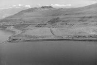
The lower strip affords access to a large, empty beach and bathing in waters that, on an average August evening, can reach temperatures in the upper 80s. The high salt content (10%) means swimming is pretty much abandoned in favor of floating.
When I land on the lower strip, I just taxi through the salt grass right up to the edge of the beach. The beach is inhabited by tiny brine flies which come from the brine shrimp that permeate the water. The flies, while sometimes thick and annoying, do not bite nor land on people. They tend to be thickest during certain times of the day early in the spring and on a few occasions, I have had to spend considerable time cleaning the plane after returning from a visit there. Most of the time however, the flies contain their activity to the immediate shoreline. If you go during the warm, late summer and decide to swim, you should be prepared to share your space with the brine shrimp in the water. They pose no threat and do not bite.
Almost all of the island, which lies approximately 35 miles to the northwest of Salt Lake City, sits outside of the Salt Lake class B airspace. However, if you approach it from the south you will either be in or under the class B most of the way. You can avoid the airspace altogether by staying on the east side of the valley and then staying low as you proceed west to the island (check the Salt Lake sectional for altitudes).
Should you decide to fly to Utah make a point to go to Fremont Island, or at very least enjoy the exhilaration of a low level circumnavigation as you tour the perimeter of the Great Salt Lake.JAt one time or another almost everyone has had the fantasy of being alone (or with someone special) on a desert island. This is a particularly difficult fantasy to fulfill, because there just isn't reliable air service or portage to most really cool deserted islands, and their remoteness makes them generally inaccessible to your average weekend warrior. That's why I was excited to discover an island getaway that is very reachable to just about anybody with a plane. |